Lessons in the Geography of the
Underground Railroad in New York State
Scenario 2: The Hudson Valleyby Timothy McDonnell
New York Geographic Alliance
STATIONS ON THE HUDSON RIVER FREEDOM TRAIL
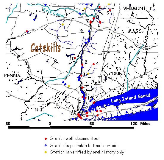
List of UGRR Stations:
| 1
- Tarrytown AME Zion Church |
6 -
Sand Lake Baptist Church |
| 2
- John Sands House (Peekskill) |
7 -
Stephen-Harriet Myers House |
| 3
- Baxtertown African-American Community |
8 -
Liberty Street Baptist Church |
| 4
- Nine Partners Meeting House (Quaker) |
9 -
Garrett Van Hoosen Homestead |
| 5
- Guinea Free Black Community |
10
- Fugitive Black Community (Hurley) |
There
are
several parts to this lesson. First you will decide on a route
for a Freedom Seeker to take on his/her way northward. Then you
will read about a real escape on the Underground
Railroad
in the Hudson Valley. You will look over some
primary sources (old map, census record, a
journal)
and see if the story makes sense. Ready? It's time to do some geography!
TASK
1: Look at the NYGA Elevation Map
(by Carol Gersmehl). What does
the landscape look like around the Hudson River Valley? Do you think
that this would affect the routes Freedom Seekers took?
TASK 2: Help plan the escape route for a Freedom Seeker:
A small group of Freedom Seekers from Maryland have arrived in Tarrytown on the Hudson River north of New York City. They were brought there by none other than Harriet Tubman herself. They stop to rest at the Foster AME Zion Church (#1). Two days later it is time to move on. The goal is to get to Troy where they will be "handled" by Henry Highland Garnet and the Liberty Baptist Church (#8). Then they will be sent across the river to Albany.
How should they get there? Do you recommend travelling on the river, or should they go overland? List the stations you will visit on the way north to Troy and Albany. Record your results on the Student Worksheet.
TASK 3: The route along the Hudson River is being watched too closely. It is too dangerous to take that route. Is there an alternative route can you take away from the river? Write your new plan on the Student Worksheet.
Primary Sources to Help in Verification
TASK 2: Help plan the escape route for a Freedom Seeker:
A small group of Freedom Seekers from Maryland have arrived in Tarrytown on the Hudson River north of New York City. They were brought there by none other than Harriet Tubman herself. They stop to rest at the Foster AME Zion Church (#1). Two days later it is time to move on. The goal is to get to Troy where they will be "handled" by Henry Highland Garnet and the Liberty Baptist Church (#8). Then they will be sent across the river to Albany.
How should they get there? Do you recommend travelling on the river, or should they go overland? List the stations you will visit on the way north to Troy and Albany. Record your results on the Student Worksheet.
TASK 3: The route along the Hudson River is being watched too closely. It is too dangerous to take that route. Is there an alternative route can you take away from the river? Write your new plan on the Student Worksheet.
TASK
4: Now that you have determined a possible escape route for a
Freedom Seeker, now it is time to compare it to an actual event in the
real Underground Railroad. To view this document, click on this link: Hudson Valley UGRR
Primary Sources to Help in Verification
| Photos of People and UGRR Stations |
Maps and Panoramic Views |
Census Records |
Documents |
| Stephen Myers Harriet Tubman Foster AME Zion Church John Sands Home Peekskill Tunnel Park Street AME Zion Church |
Peekskill Panoramic Map Albany Panoramic Map Map of Part of Troy 1855 Tarrytown Map 1845 |
Troy 1860 Census Page Tarrytown 1860 Census Page |
Quotes on the Charles Nalle Rescue |
Make
sure you answer the questions on the Student Worksheet from Task 4.
This includes filling in the chart on the primary sources included in
this web page.
CONCLUSIONS: The wrap-up of this activity will be done as a class. Make sure you participate in the class discussion!
CONCLUSIONS: The wrap-up of this activity will be done as a class. Make sure you participate in the class discussion!
Return to the Underground Railroad Lessons Page
Return to the New York Geography Homepage
Contact Us!