Lessons in the Geography of the
Underground Railroad in New York State
Scenario 4: Central New Yorkby Timothy McDonnell
New York Geographic Alliance
STATIONS ON THE CENTRAL NEW YORK TRAIL
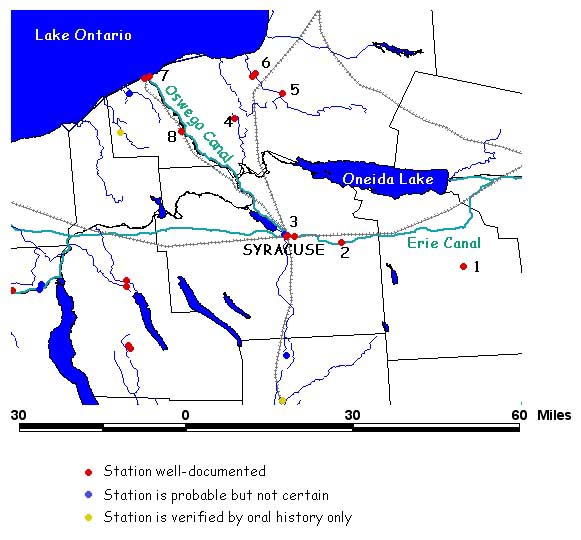
List of UGRR Stations:
| 1
- Gerrit Smith Estate (Peterboro) |
5 -
Asa Wing House (Parish) |
| 2
- Old
Stone Library (Fort Ann) |
6 -
Orson Ames Home (Mexico) |
| 3
- Jermain
Loguen Home (Syracuse) |
7 -
Littlefield Home (Oswego) |
| 4
- Bristol Congregational Church (Volney) |
8 -
Case House (Fulton) |
There
are
several parts to this lesson. First you will decide on a route
for a Freedom Seeker to take on his/her way northward. Then you
will read about a real escape on the Underground
Railroad in the Greater Syracuse Area. You will look over some primary
sources (old map, census record, a journal) and see
if the story makes sense. Ready? It's time to do some geography!
TASK
1: Look at the NYGA Elevation Map
(by Carol Gersmehl). What does
the landscape look like in the Central New
York region? Do you think that this would affect the routes Freedom
Seekers
took?
TASK 2: Help plan the escape route for a Freedom Seeker:
One of the safest places for a fugitive was probably at Gerrit Smith's estate in Peterboro (#1). It was said that, "There are two places a slave holder cannot go, Heaven and Peterboro." Even so, there was a young African-American hiding there that needed to continue on his journey to Canada. The Smith family thinks the best route is to Syracuse (#3) and then on to the lake port of Oswego (#7). Does this sound good to you?
The details of this journey is up to you! Record your itinerary on the chart on your Student Worksheet.
TASK 3: The harbor at Oswego is being patrolled too closely. You need to send the Freedom Seeker somewhere else. What alternative route can you take? Write your new plan on the Student Worksheet.
Primary Sources to Help in Verification
TASK 2: Help plan the escape route for a Freedom Seeker:
One of the safest places for a fugitive was probably at Gerrit Smith's estate in Peterboro (#1). It was said that, "There are two places a slave holder cannot go, Heaven and Peterboro." Even so, there was a young African-American hiding there that needed to continue on his journey to Canada. The Smith family thinks the best route is to Syracuse (#3) and then on to the lake port of Oswego (#7). Does this sound good to you?
The details of this journey is up to you! Record your itinerary on the chart on your Student Worksheet.
TASK 3: The harbor at Oswego is being patrolled too closely. You need to send the Freedom Seeker somewhere else. What alternative route can you take? Write your new plan on the Student Worksheet.
TASK
4: Now that you have determined a possible escape route for a
Freedom Seeker, now it is time to compare it to an actual event in the
real Underground Railroad. To view this document, click on this link: Jerry Rescue
Primary Sources to Help in Verification
Make
sure you answer the questions on the Student Worksheet from Task 4.
This
includes filling in the chart on the primary sources included in
this web page.
CONCLUSIONS: The wrap-up of this activity will be done as a class. Make sure you participate in the class discussion!
CONCLUSIONS: The wrap-up of this activity will be done as a class. Make sure you participate in the class discussion!
Return to the Underground Railroad Lessons Page
Return to the New York Geography Homepage
Contact Us!